Social Media Picasa Youtube

Idaho Fire Incident Map

Showing posts with label Payette. Show all posts

Wednesday, September 4, 2019

Nethker Fire 100% Contained


McCall, ID, September 4, 2019- The Nethker Fire achieved 100% containment on September 3, 2019 - this will be the last update for this fire unless a future update is warranted. A local Type 5 incident organization is managing the fire now, and fire personnel remain on site to monitor and patrol the fire area.

Even as the fire has been declared 100% contained, the August 30 Area Closure remains in effect for public safety. Fire wood cutting is not allowed in the closed area. The closed area is defined as all areas of the Nethker fire that have burned.

Burgdorf/French Creek Road, Warren Wagon Road, Crystal Mountain Road, Burgdorf Creek Road and Ruby Meadows Road (to the trailhead) are open for public travel. The 251 Road/OHV trail #174 remain closed as they are fully within the burned area.

Ruby Meadows road is open, but the first part of the road is surrounded by burned trees and vegetation - stay out of the burned area and drive past the burned area before getting out of your vehicle.

Jeanette Campground and Burgdorf Campground are open for public use; however, the fire area is closed - do not enter the burned area and no camping is allowed within the burned area. The burn area remains closed due to the potential for falling snags as this creates danger - no fuel wood cutting within the burned area.
Drive cautiously through the burned area as the potential for falling snags is a hazard.

Smith Knob Fire:  The fire is now 769 acres.  An infrared flight was conducted last night.  There was minimal fire behavior yesterday with smoldering and creeping, and short surface fire runs occurred where fuels, wind, and topography aligned.   

The fire will continue to be actively monitored today and point protection measure are in place.  Resources assigned include Bonneville IHC, 1 Type 3 helicopter, and 5 single resource personnel. 
An Area Closure remains in effect for this fire.  For more information, visit this page on Inciweb:  https://inciweb.nwcg.gov/incident/6550/   


Thursday, August 15, 2019

Nethker Fire Update for August 15th, 2019

The #NethkerFire is now 68 percent contained as crews continue to make progress in the northern area of the fire. Some islands of previously unburned vegetation inside the fire perimeter burned yesterday, leading to a small increase in the size of the fire to 2,351 acres.

The Warren Wagon Road is open to the public, however, the French Creek/Burgdorf Road remains closed. With increased weekend traffic, please drive with caution. Firefighters and their vehicles will be working in the area.
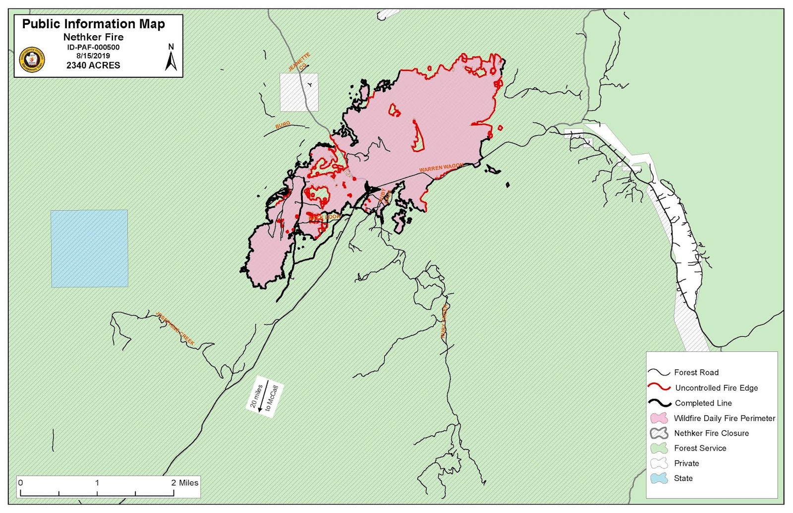
Nethker Fire Map as of August 15,2019.
Smoke will be visible along the road and within the interior of containment lines. These areas have been secured and firefighters will continue to extinguish them.

Temperatures are expected to be cooler today over the fire today reaching mid 70s with increased humidity and cloud cover. There is a slight chance of afternoon thunderstorms, which could bring gusty winds. Fire behavior will continue to moderate with creeping and smoldering in the heavy fuels. There is a possibility of torching as interior pockets continue to burn.
Firefighters have moved into the mop-up stages of securing the fireline on the southern end of the Nethker Fire, looking for hot spots and putting them out. Part of this work will also include repairing suppression lines to help mitigate the impact of firefighting efforts. Hotshot and helitack crews continue to build line along the northwest and east sides of the fire where it has burned into the old Burgdorf burn scar and along the Warren Wagon Road to the east.

Wildfire defense plans for the communities of Secesh and Burgdorf are complete. So far successful containment lines on the Burgdorf side of fire have reduced threats to the area. At this time, there is no immediate threat to Secesh; however, firefighters are ready to move into the area if fire activity makes it necessary to do so.

Closures: There is an area closure in effect for Forest Service land. Popular areas affected by this closure include: Trail Lake, Summit Lake, Lake Rock, Josephine Lake, Frosty Meadow, Ruby Meadows to Loon Lake (Loon Lake remains open), Crystal Mountain, and Bear Pete Mountain. Chinook Campground is open with access only from Warren. The closure order and map can be found here: http://bit.ly/NethkerFireAreaClosure2.  

A TFR (Temporary Flight Restriction) has been implemented over the fire area - which means recreational drones and private aircraft may not be operated over the fire. The TFR can be found here: https://tfr.faa.gov/save_pages/detail_9_4931.html.

Please check the Nethker Fire’s page on Inciweb or the Payette National Forest Facebook page for updated information, along with the latest maps and photos.

Saturday, August 10, 2019

Thunderstorms, Rain Predicted for Nethker Fire Area


A Red Flag warning remains in effect today due to the threat of thunderstorms that could produce winds up to 45 mph accompanied by marble-size hail. The winds could accelerate fire activity and movement; however, cooler, wetter weather is also in the forecast. This is expected to moderate fire activity and decrease the potential for spot fires.
The fire size is estimated at 2,000 acres and is 27 percent contained. An infrared flight over the fire, which would provide a more accurate acreage, could not take place overnight due to cloud cover.
Nethker Fire map as of August 10, 2019.
A community meeting will be held tonight at 7 p.m. at the Secesh Fire Department. The fire is not threatening the community of Secesh; however, firefighters continue to update existing structure assessments to determine the need for wildland fuels reduction around structures. This measure is precautionary and can be used for future planning.
Crews made good progress Friday on the southern end of the fire. Firefighters will continue to work the west and east sides of the fire with help from aircraft to contain existing spot fires and build containment line.
The Warren Wagon Road north of McCall is closed to individuals who do not have property in the area. Incident personnel are staffing roadblocks north of Secesh Summit and south of Grouse Creek. This is subject to changed based on fire activity. Delays may occur while property owners wait for the pilot car to escort them.

The Burgdorf/French Creek Road also remains closed from the Warren Wagon junction to Corduroy.
 An existing area closure for Forest Service land has been expanded. Popular areas affected by this closure include: Trail Lake, Summit Lake, Lake Rock, Josephine Lake, Frosty Meadow, Ruby Meadows to Loon Lake (Loon Lake remains open), Crystal Mountain, and Bear Pete Mountain. Chinook Campground is open with access only from Warren. The closure order and map can be found here: http://bit.ly/NethkerFireAreaClosure2.

A TFR (Temporary Flight Restriction) has been implemented over the fire area - which means recreational drones and private aircraft may not be operated over the fire. The TFR can be found here: https://tfr.faa.gov/save_pages/detail_9_4931.html.

Wednesday, August 7, 2019

Community Meeting Set for Tonight at Secesh Fire Station for the Nethker Fire


Fire activity on the #NethkerFire increased Tuesday afternoon, pushing the fire north to within less than a mile of the Forest Service Guard Station, which is south of Burgdorf Hot Springs.

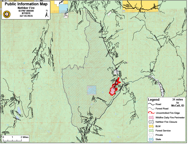
Nethker Fire map as of August 7, 2019.
Great Basin Incident Management Team 3 took command of the fire at 10 p.m. Tuesday. The team will hold a community meeting tonight at 7 p.m. at the Secesh Fire Station to provide additional information about the Nethker Fire.

Firefighters will concentrate today on the north and east sides of the fire, defending the widely popular Burgdorf Hot Springs, the Guard Station, road access to the communities of Secesh and Warren, and the area’s anadromous fish resources. The west side of the fire has not shown growth over the past few days.

Fire traffic is heavy along the Warren Wagon and Burgdorf/French Creek roads. These roads are open, but the public is not allowed to remain at the point where they intersect. The public is encouraged to avoid this area, if possible, for their safety and the safety of firefighters.

 A TFR (Temporary Flight Restriction) has been implemented over the fire area - which means recreational drones and private aircraft may not be operated over the fire. The TFR can be found here: https://tfr.faa.gov/save_pages/detail_9_4931.html. 

No evacuations have been ordered by the Idaho County Sheriff at this time. An area closure for Forest Service land is in effect that covers Jeanette Campground and dispersed camping along Warren Wagon Road, Burgdorf/French Creek Road, Lake Creek and Summit Creek.

Today’s forecast calls for partially sunny skies with light winds. Fire behavior is expected to be low to moderate. There is an increasing chance of thunderstorms over the next few days, with potential for wetting rains and cooler temperatures by the end of the week.

Inciweb address: https://inciweb.nwcg.gov/incident/6496/
Phone: 208-634-0820
Start Date: Aug. 4, 2019
Cause:  Lightning 
Acres: 327
Percent Contained: 0%  


Tuesday, August 6, 2019

Firefighters Continue to Make Progress While Addressing an Early Evening Surge in Fire Activity


Fire activity on the Nethker Fire was light through the majority of the day which allowed firefighters to make good progress on the fire containment, however; as the cloud cover left the fire area, fire activity increased.  With the sun warming the fire area, spotting outside the main fire area and tree torching began.  As the current cloud cover moved in the area, the winds shifted to the south southwest and pushed to fire to the south side of Nethker Creek in the direction of the Warren Wagon Road and Burgdorf/French Creek Road intersection.  As the cloud cover cooled the fire, fire activity decreased and returned to light to moderate burning that is occurring now. 

Traffic control has been implemented on the Burgdorf/French Creek road as firefighting resources moved to the intersection to better position themselves fight the fire.  Unfortunately, members of the public in the area impeded fire traffic and traffic control measures were necessary.  We are asking members of the public to stay out of the intersection area as the movement of fire resources is critical to our firefighting efforts.

The fire is estimated to be at 350 acres and an IR Fight is schedule for tonight which will help in mapping the fir perimeter.

No evacuations have been order by the Idaho County Sheriff at this time.  An area closure for Forest Service land is in effect that covers Jeanette Campground and dispersed camping along Warren Wagon Road, Burgdorf/French Creek Road, Lake Creek and Summit Creek.  Warren Wagon Road and Burgdorf/French Creek Road remain open, but member of the public will not be allowed to remain the intersection area.

Fire Restrictions:  No Fire Restrictions are in effect at this time. 

Monday, August 5, 2019

Firefighters Held the Nethker Fire to Minimal Growth Today

The Nethker fire actively burned through the afternoon, yet firefighters were able to hold the fire west of Warren Wagon Road and southwest of Burgdorf. With improved mapping and fire activity today, the fires is at 249 acres. Aerial resources again played a vital role in supporting ground based firefighters in keeping this fire small. 
An area closure for Forest Service land is in effect that covers Jeanette Campground and dispersed camping along Warren Wagon Road, Burgdorf/French Creek Road, Lake Creek and Summit Creek. Warren Wagon Road and Burgdorf/French Creek Road remain open. 
Great Basin Incident Management Team 3 (Type 2) in-briefed tonight, will shadow fire managers tomorrow, and assume command of the fire on August 6 at 9p.m. The Incident Command Post will be in the McCall area, with spike camps near the fire area. 230 firefighters and support personnel are assigned to the fire. A Haines Index 4 is expected over the fire area tomorrow meaning potential fire growth is moderate to low. 
 Inciweb link -  https://inciweb.nwcg.gov/incident/6496/
Fire Restrictions:  No Fire Restrictions are in effect at this time.   

Payette National Forest Fire Update - NETHKER FIRE UPDATE


The Nethker Fie was detected at 2:20p.m. yesterday, August 4.  The Fire continues to hold while actively burning through the night.  Firefighter staffed the fire throughout the night to prep the area for today's operations.  Mapped acreage shows the fire at 100 acres. A heavy presence of firefighting resources will be on-scene today, with additional resources arriving throughout the day. This is a full suppression fire with the intent to control the fire as quickly as possible. Today’s weather forecast equates to a potential for fire growth and new fire starts. An area closure will be enacted this morning, but the Burgdorf-French Creek Road and Warren Wagon Road remain open at this time. Contact Burgdorf Hot Springs directly to inquire if they are open for business today.


We have a Haines Index of 5 today over the Nethker Fire area. Haines Index (also known as Lower Atmosphere Severity Index) is a weather index developed by meteorologist Donald Haines in 1988 that measures the potential for dry, unstable air to contribute to the development of large or erratic wildland fires.

A Haines Index of 6 means a high potential for an existing fire to become large or exhibit erratic fire behavior, 5 means medium potential, 4 means low potential, and anything less than 4 means very low potential.

A Type 2 Incident Management Team has been assigned and in-brief this evening in McCall.

Follow the https://www.facebook.com/payettenationalforest/ for the latest updates or on Inciweb at https://inciweb.nwcg.gov/incident/6496/.

Tuesday, August 14, 2018

Vale BLM sponsoring Women in Wildland Fire Boot Camp

Cool opportunity being hosted by our neighbors!
Oregon/Washington 
For immediate release                                                                               
Contact: Larisa Bogardus 541-947-6811
August 14, 2018                                                                                                          
Vale BLM sponsoring Women in Wildland Fire Boot Camp

VALE, Ore. - The Vale District of the Bureau of Land Management (BLM) is committed to keeping public landscapes healthy and productive and is offering paid training for women interested in a career in wildland fire management.
In addition to controlling and suppressing wildfires that threaten communities and natural resources, wildland firefighters play a key role in using fire strategically to manage sustainable, working public lands.
Upon completion of the Women in Wildland Fire Boot Camp, participants will have fulfilled several key entry-level training requirements for seasonal employment by federal agencies or private contractors. Training is a combination of classroom instruction and hands-on field exercises ranging from firefighting techniques, tools and equipment to communications and safety.

Applications will be accepted through Sept. 14 and selections will be made by Sept. 21. The boot camp will be held near Juntura, Ore., over two consecutive weekends, October 19-21 and October 26-28. Students will be paid for their time at camp, Application deadline is September 14th. Selections will be made by September 21st. Students will be paid $12.74 per hour for training time. Training materials, personal protective equipment and meals will be provided.
The complete outreach notice and application can be requested by calling 541-473-6297 or emailing candrews@blm.gov For more information, contact Cassandra Fleckenstein at 541-473-6295.

-BLM-


Saturday, August 11, 2018

Mesa Fire Update - August 11th

PUBLIC MEETING -- TODAY, AUGUST 11, 7:00 P.M., Council Elementary School                                                                             
FIRE UPDATE:   Yesterday’s high in Council was 105, breaking the record temperature of 103 degrees for August 10th. Engines and handcrews continued to hold and secure the northeastern perimeter by removing burning materials near the fire edge. After a successful 350 acre burnout operation in Cookhouse Gulch, crews have been working to achieve containment with the assistance of helicopter water bucket drops. Engine crews completed a hose lay along the 200 Road in preparation for potential firing operations this evening if conditions are favorable. Today, crews continue to work interior hotspots within the northeast and southeast portions of the fire in an effort to further secure the line. Several engines will continue to patrol the western flank of the fire.
A red flag warning has been issued by the Mesa Fire Incident Meteorologist between 11:00 a.m. and 9:00 p.m. today due to the consecutive days of low humidity and increased winds. A dry cold front will move through today resulting in strong southwest winds of near 15 mph with gusts of over 30 mph possible. Incident resources will focus efforts on holding the fire given the potential for increased fire behavior.
Forecasted weather after today is more favorable for containment efforts.
Please use caution when traveling in the area and be aware of fire traffic.
 
TEMPORARY FLIGHT RESTRICTIONS: Temporary flight restrictions (TFR) are in effect over the entire fire area. Remember, temporary flight restrictions also apply to unmanned aircraft systems (drones), so if you fly, we can’t!
 
FIRE RESTRICTIONS: Central Idaho, including the Payette National Forest, is under Stage I Fire Restrictions. For more information please visit: https://www.idahofires.com/search/label/Payette
 
UPDATED CLOSURE: An updated Forest Closure Order is in effect (#0412-524) for areas within and surrounding the Mesa Fire.
For more information visit: https://inciweb.nwcg.gov/incident/article/6041/45447

Wednesday, August 1, 2018

FIRE RESTRICTION INFORMATION UPDATE

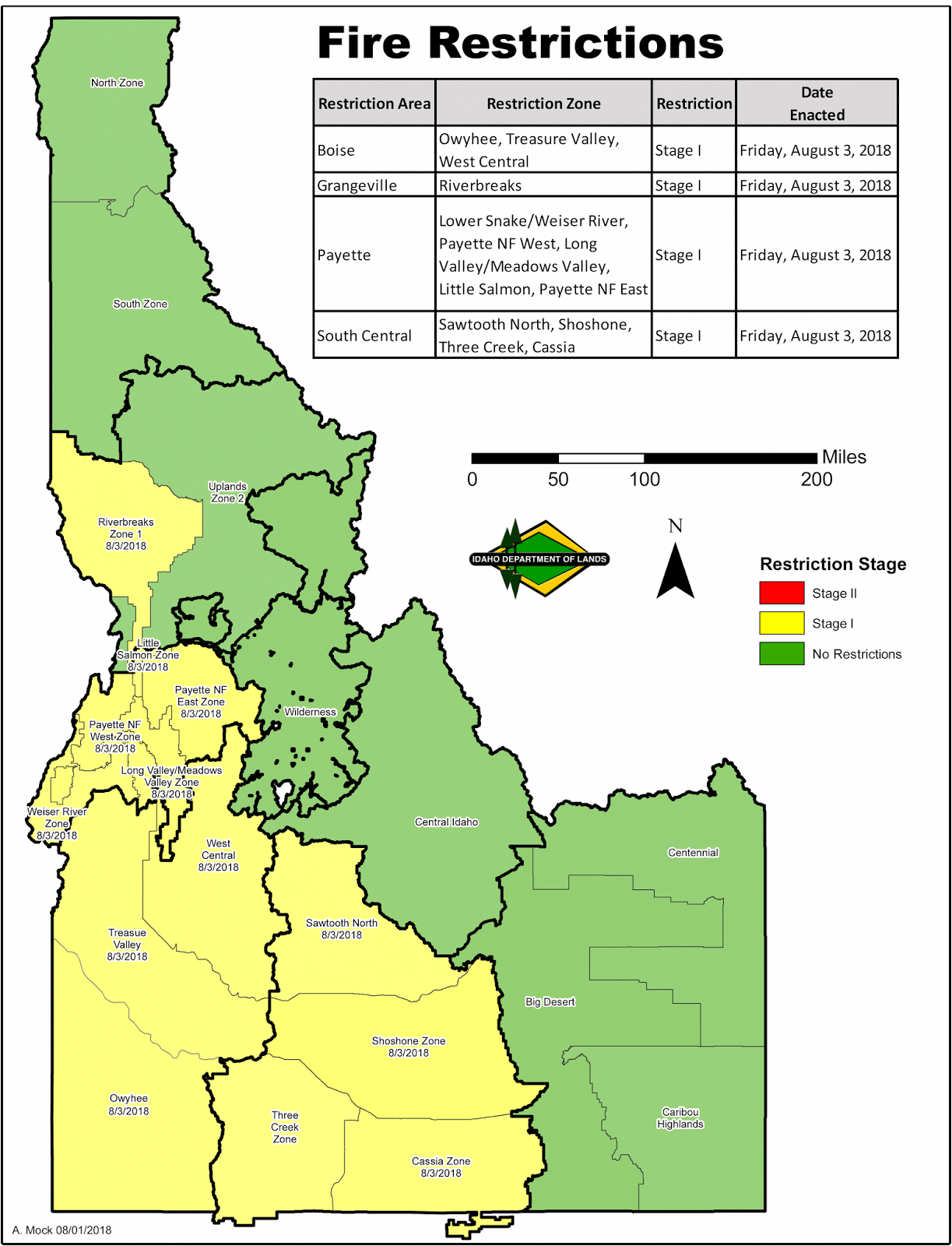
Effective at 1 minute after midnight on Friday morning, August 3, 2018, the Payette Fire Restrictions Area, Boise Fire Restrictions Area, South Central Fire Restrictions Area, and the Riverbreaks Zone of the Grangeville Fire Restrictions Area will be in Stage I Fire Restrictions.

Friday, July 27, 2018

STATE PROTECTION FIRES IN IDAHO

INCIDENT OVERVIEW - MM73 HWY 55 FIRE

The Mile Marker 73 Highway 55 Fire near Gardena showed little movement to the east overnight due to cooler overnight temperatures and higher humidities found along the Payette River Corridor. Crews continued to work through the night constructing fire line along the eastern perimeter while mopping up the southern area along Highway 55. Today, crews will continue to construct fire line to the east with support from water dropping helicopters which will continue to take advantage of the main Payette River and its close proximity to the fire area.
At 6:00 am this morning, Great Basin Incident Management Team #2 (DeMasters) will assume command of the Mile Marker 73 Highway 55. The addition of the incident management team to the fire will secure additional personnel and equipment which will allow local resources to be released for other initial attack activity in their local response area.

Highway 55 is reopened in both directions with no restrictions. The public is also reminded that numerous hazards exist along Highway 55 including fire personnel, helicopters dipping water from the river and the possibility of falling rock and debris loosened by the fire. Drivers need to be aware of the possible hazards and drive with caution.

The fire was reported Wednesday, July 25th, at approximately 4 P.M. The cause is under investigation.  Anyone with information regarding this fire is asked to call the Idaho Department of Lands Fire Investigation Hotline at 208-666-8695.

INCIDENT OVERVIEW - TRESTLE FIRE

July 27, 2018 8:00 AM
(Boise) - The Trestle Fire, located mainly on private and some Boise National Forest land, has had no significant growth in the last 24 hours. The fire is approximately 220 acres and 60% contained.
Resources today include the Idaho Department of Lands Type 3 Incident Management Team, three engines, a dozer, and 7 hand crews.
The Cabarton Road boat launch remains closed and boating is prohibited below the ramp due to firefighting activity. There are no evacuations, road or trail closures ordered at this time. No structures are threatened.
The fire was reported on Monday, July 23, just before 5 P.M. It started about four and a half miles north of Smith’s Ferry on the bank of the North Fork of the Payette River. The cause of the fire is under investigation.  Anyone with information regarding this fire is asked to call the Idaho Department of Lands Fire Investigation Hotline at 208-666-8695.
Idaho Department of Lands media contact: 208-334-0233, fireinformation@idl.idaho.gov

Friday, September 15, 2017

Land Management Agencies lift Stage 1 Fire Restrictions in most zones of the Payette Fire Restriction Area


McCall, Idaho - With cooler temperatures and chances of precipitation increasing into next week, local land management agencies will lift Stage 1 Fire Restrictions in the Payette West, Payette East, and Long Valley/Meadows Valley Zones of the Payette Fire Restriction Area beginning Friday, September 15, 2017. The Fire Restrictions are rescinded by agencies managing state, private and public lands in the area, including the United States Forest Service (USFS), Southern Idaho Timber Protective Association (SITPA), and the Idaho Department of Lands (IDL).  Restrictions were terminated in the Weiser River Zone of the Payette Fire Restriction Area on Wednesday, September 13, 2017.
The Little Salmon Zone of the Payette Fire Restriction Area remains in Stage 1 fire restrictions until further notice. See map below for location.
The restrictions were put into effect on August 11 when fire danger and burning conditions were unusually high. Recent storms have brought some moisture with much cooler temperatures to the area, and with the days getting shorter fire conditions have moderated. Forest visitors are reminded that vegetation is still dry and to be careful with all use of fire in the outdoors.  The accidental start of a wildfire can still be devastating.  Be alert and be aware.  Follow these tips to help prevent wildfire:
  • NEVER leave a camp fire unattended
  • Keep water, dirt and a shovel near your fire at all times
  • Make sure your fire is dead out and cold to the touch before you leave it
  • Use of fireworks, exploding targets or tracer rounds is prohibited on public lands
Area closures due to active wildfires are still in effect on some public lands, including the area affected by the Highline Fire on the Payette National Forest.  Contact the land management agency for your area of interest for specific information regarding fire closures.

Fire restrictions may be lifted but burn bans may still be in place in some areas. Fire restrictions and burn bans address different types of activities. Burn bans pertain to controlled burning activities such as debris burning, slash burning, or agricultural burning, for which a fire safety burn permit from IDL is required. Visit http://burnpermits.idaho.gov/ for more information.

Sunday, September 10, 2017

Highline Fire Update for September 10


Location: The Highline Fire and Goat Fire are both burning on the Payette National Forest, Krassel Ranger District, entirely within the Frank Church River of No Return Wilderness (https://tinyurl.com/y8qomgpm), approximately 23 miles east/northeast of Warren, Idaho. 

Date of Origin: July 28, 2017 @ approx. 7:00 p.m.
Cause: Started by lightning
Current Size: Highline Fire: 82,133 acres / Goat Fire: 788 Acres 

Current Situation: The Highline and Goat Fires received spotty precipitation yesterday ranging from none to one half of an inch in a few isolated areas. The moisture and lower temperatures resulted in minimal fire activity in areas with lighter fuels such as grass. Active burning persisted in areas with heavier fuels such as blow down which are less affected by small amounts of precipitation. A community meeting was held in Big Creek for residents in the nearby area. Firefighters worked in the Beaver Creek area north of Edwardsburg to set up gravity fed sprinkler systems on bridges and at structures to provide protection should the fire advance into the area. Assessments were conducted at the Snowshoe Mine to determine what protection actions would be appropriate in the area. Fire managers were able to fly over the entire perimeter of the Highline and Goat Fires to see areas that had been covered in smoke for days. An infrared flight last night also provided key intelligence to those working on the incident. The fire has made its way to the Rock Rabbit Lookout where natural barriers and scabby fuels coupled with structure wrap on the lookout have protected the building. Forecasts for Sunday indicate a similar weather pattern to that ofSaturday with a drier trend setting up Monday and Tuesday. Firefighters will be positioned at Big Creek to monitor the fire’s movement to the southwest. A crew remains vigilant at Root Ranch monitoring the fire, ready to take action if needed. Resources assigned to the fire include one type 2 initial attack crew, one local hand crew, one light helicopter and multiple fireline leadership and support positions. A total of 76 personnel are assigned. 
Fire Management Strategy: The Payette National Forest has selected a monitor/point protection fire management strategy as the fire is burning within the Wilderness and was started naturally by lightning. This management approach allows fire to play its natural role in the Wilderness to achieve ecological benefits for enhancement of forest health and wildlife habitat, while protecting Values at Risk. Suppression actions will be taken as needed to protect Values at Risk. 
Closures and Restrictions: A Forest Area Closure is in effect for public and firefighter safety. Included in the closure area, Chamberlain, Cold Meadows, Soldier Bar and Cabin Creek Airstrips are closed due to fire activity. Please visit the following link for the Highline Fire Area Closure Order: https://inciweb.nwcg.gov/incident/article/5500/40016/. The Payette National Forest is also under STAGE 1 FIRE RESTRICTIONS. Click this link for designated sites where campfires are allowed. If a site is not signed as being a designated site, then campfires are not allowed at that site. There are no fire restrictions in the Frank Church River or No Return Wilderness. For more information: https://www.idahofires.com/p/wilderness-fire-restrictions.html. 

For More Information: Follow the Payette National Forest on Twitter at @Payette Forest, and on Facebook at U.S. Forest Service - Payette National Forest. Subscribe to email updates via GovDelivery at https://goo.gl/R2fDJr. If you have a question, please email us at payettefireinformation@gmail.com. Visithttps://inciweb.nwcg.gov/incident/5500/ for more information on the Highline and other fires throughout the nation and www.idahofireinfo.com for information on fires throughout the state of Idaho.