


Showing posts with label Wildfires. Show all posts
Showing posts with label Wildfires. Show all posts
Friday, August 24, 2018
Idaho DEQ extended the Air Quality Forecast and Caution for the Twin Falls area and surrounding counties
The Idaho DEQ is extending the Air Pollution Forecast and Caution for Cassia, Gooding, Jerome, Lincoln, Minidoka, and Twin Falls Counties due to continued degraded air quality from wildfire smoke. The next update is Monday, August 27th at 12: p.m.

Thursday, August 23, 2018
Rabbit Foot Fire Update - August 23rd
| |||||
|

Wednesday, August 22, 2018
Saturday, August 11, 2018


Mesa Fire Update - August 11th
PUBLIC MEETING -- TODAY, AUGUST 11, 7:00 P.M., Council Elementary School
FIRE UPDATE: Yesterday’s high in Council was 105, breaking the record temperature of 103 degrees for August 10th. Engines and handcrews continued to hold and secure the northeastern perimeter by removing burning materials near the fire edge. After a successful 350 acre burnout operation in Cookhouse Gulch, crews have been working to achieve containment with the assistance of helicopter water bucket drops. Engine crews completed a hose lay along the 200 Road in preparation for potential firing operations this evening if conditions are favorable. Today, crews continue to work interior hotspots within the northeast and southeast portions of the fire in an effort to further secure the line. Several engines will continue to patrol the western flank of the fire.
search/label/Payette
incident/article/6041/45447
Goose Rapids Fire Update - August 11th AM
(Boise) - The Goose Rapids Fire held in place overnight. A better acreage estimate of 600 acres was observed via aircraft fly-over today. Resources continue to be engaged in structure protection operations including a type three (3) incident team, and an additional hand crew was added.
Evacuations remain in effect for residences along Idaho side of Snake River, from Corral Creek to Dough Creek per the Nez Perce County Sheriff. Zaza Road is closed at Deer Creek Road and Zaza Road Intersection.
Idaho Department of Lands (IDL) together with the U.S. Forest Service, the Clearwater-Potlatch Timber Protective Association (CPTPA) and the Nez Perce County Emergency Management Services, continue to battle the fire that started 21 miles south of Lewiston near Wild Goose Rapids on the Snake River, approximately 1 mile north of China Garden Creek in Nez Perce County.
Critical fire weather conditions are expected again today. Very hot temperatures in the 90’s to 100s and red flag warnings are in effect until 8 p.m., with sustaining west winds of 10-20 mph.
Seven engines, two bulldozers, two hand crews are on scene. Approximately ten aircraft including one Air Attack, three helicopters, two Single Engine Air Tankers (SEATs), and four large air tankers will continue suppression of the fire and logistically support the ground resources.
Stage 1 Fire Restrictions continue to be in effect for this portion of the River Breaks which prohibits the building of any campfires outside of a permanent agency owned fire structure as well as smoking. Smoking is prohibited except within an enclosed vehicle, building or designated recreation site, or while stopped in an area at least three feet in diameter that is barren or cleared of all flammable materials.
The cause of the fire is currently under investigation.
Inciweb link: https://inciweb.nwcg.gov/incident/6123/

Evacuations remain in effect for residences along Idaho side of Snake River, from Corral Creek to Dough Creek per the Nez Perce County Sheriff. Zaza Road is closed at Deer Creek Road and Zaza Road Intersection.
Idaho Department of Lands (IDL) together with the U.S. Forest Service, the Clearwater-Potlatch Timber Protective Association (CPTPA) and the Nez Perce County Emergency Management Services, continue to battle the fire that started 21 miles south of Lewiston near Wild Goose Rapids on the Snake River, approximately 1 mile north of China Garden Creek in Nez Perce County.
Critical fire weather conditions are expected again today. Very hot temperatures in the 90’s to 100s and red flag warnings are in effect until 8 p.m., with sustaining west winds of 10-20 mph.
Seven engines, two bulldozers, two hand crews are on scene. Approximately ten aircraft including one Air Attack, three helicopters, two Single Engine Air Tankers (SEATs), and four large air tankers will continue suppression of the fire and logistically support the ground resources.
Stage 1 Fire Restrictions continue to be in effect for this portion of the River Breaks which prohibits the building of any campfires outside of a permanent agency owned fire structure as well as smoking. Smoking is prohibited except within an enclosed vehicle, building or designated recreation site, or while stopped in an area at least three feet in diameter that is barren or cleared of all flammable materials.
The cause of the fire is currently under investigation.
Inciweb link: https://inciweb.nwcg.gov/incident/6123/
Saturday, August 4, 2018
Wildfire Prevention and Education Team Mobilized
FOR IMMEDIATE RELEASE
August 3, 2018
Contact: Melissa Yunas
Wildfire Prevention and Education Team Mobilized
TWIN FALLS, IDAHO -
As extreme wildfire conditions increase across Idaho, the Bureau of Land
Management mobilized a Wildland Fire Prevention Education Team to enhance
ongoing local wildfire outreach prevention efforts. August 3, 2018, the team
was tasked to raise awareness of Idaho’s
wildfire threat from target shooting and enlist the public’s support to take
personal responsibility to reduce wildfire risks. For the first few days, the
team will concentrate their efforts in and around the Twin Falls area.
“August
is typically the peak month for wildfire activity,” explained Fire Prevention
Team Lead Zachary Ellinger. “Since January 2018, the Bureau of Land Management
responded to approximately 70 human-caused wildfires that have burned over
29,000-acres (which includes the Sharps Fire near Bellevue). As a community, we
can reduce future wildfires by taking a few extra precautions.”
Using
recent fire behavior, ignition research and historical fire occurrences, the Fire
Prevention Education Team will emphasize the Shoot Responsibly-Idaho statewide initiative campaign. The campaign
is designed to provide constant reminders during this fire season to reduce the
number of target shooting fires throughout the state. Since 2015, over 30%
percent of wildfire ignitions in Idaho were attributed to exploding target and
ammunition sparking off rocks and other hard-surfaced materials (metal
targets). Outdoor shooting enthusiasts are encouraged to use public lands
safely, while following the current fire restrictions and incorporating
wildfire safety practices into their routine.
Until the fire threat is diminished, all
Idahoans can take steps to prevent the next wildfire from occurring.
One less spark means one less wildfire;
let’s all do our part.
--END-
Wednesday, August 1, 2018
Stage 1 Fire Restrictions ordered for south central Idaho
News Release
DATE: August 1,2018 CONTACT:
Sharla Arledge (IDL)- 208-334-0233
Kelsey
Brizendine (BLM)- 208-732-731
Julie Thomas (Forest)-208-423-7500
Stage 1 Fire
Restrictions ordered for south central Idaho
SHOSHONE, Idaho-- As the threat of
wildfire danger continues to increase, state and federal land management
agencies will implement Stage 1 Fire
Restrictions on lands within south central Idaho effective August 3, 2018
at 12:01 a.m. Fire restrictions are intended to decrease
the chance of any preventable fires in the designated areas.
Stage 1 fire restrictions will be in place
on federal, state and private forest and rangelands, roads, and trails,
situated in Blaine, Camas, Cassia, Custer,
Elmore, Gooding, Jerome, Lincoln, Minidoka, Owyhee, and Twin Falls counties.
These restrictions
are being implemented by agencies managing or providing wildland fire
protection, which include the Sawtooth National Forest, Twin Falls District Bureau of Land Management
and the Idaho Department of Lands (IDL). These restrictions are separated into Zones
and described as follows:
Zone
1 - Sawtooth North
All Sawtooth National Forest, Twin
Falls District BLM, and Idaho State lands north of Highway 20 to the northern
most Sawtooth National Forest boundary.
From Hill City east to the Craters of the Moon National Monument and
Reserve Visitor Center.
Zone 2 -- Shoshone
All Twin Falls
District BLM and Idaho State lands north of I-84 to Highway 20. From King Hill
east to Massacre Rocks State Park.
Zone 3 -- Three Creek
All Twin Falls
District BLM and Idaho State lands from I-84 south to Idaho/Nevada border. West
of Highway 93 to the Bruneau Canyon
Zone
4 - Cassia
All Twin Falls District BLM and
Idaho State lands from I-84/I-86 south to Idaho/Utah/Nevada border. East of
Highway 93 to the Cassia County/Oneida County line. All lands administered by
the Minidoka Ranger District, Sawtooth National Forest.
**National Park Service managed units including Craters of
the Moon National Monument and Preserve, Hagerman Fossil Beds National
Monument, and Minidoka National Historic Site are also under Stage 1 Fire
restrictions
Under the Stage 1
Fire Restrictions, the following acts are prohibited on state and federally
managed or protected lands, roads, and trails:
·
Building,
maintaining, attending, or using a fire, campfire or stove fire except within a designated recreation
site and in a permanent concrete or metal fire ring, or on private land, and
only within an owner-provided structure.
·
Smoking,
except within an enclosed vehicle, building, or designated recreation site, or
while stopped in an area at least three feet in diameter that is barren or
cleared of all flammable materials.
The following are
exemptions to the Stage 1 Fire Restrictions:
·
Persons
with a written permit that specifically authorizes the otherwise prohibited
act.
·
Persons
using fire fueled solely by liquid petroleum or liquid petroleum gas (LPG)
fuels. Such devices, including propane
campfires, may be used only in an area cleared of flammable material.
·
Persons
conducting activities in those designated areas where the activity is
specifically authorized by written posted notice.
·
Any
federal, state or local officer or member of an organized rescue or
firefighting force in the performance of an official duty.
·
All
land within a city boundary is exempted.
·
Other
exemptions unique to each agency.
Fire
managers are asking the public to be extra cautious when spending time in the
outdoors. As a reminder, fireworks are
prohibited on state and private forestland and rangeland during closed fire
season (May 10 through Oct. 20), and on public lands, roads and trail in Idaho
all times of the year.
Controlled
burning restrictions may be in place due to air quality through the Idaho
Department of Environmental Quality. Information about DEQ burn bans is
available here: http://deq.idaho.gov/air-quality.aspx. The IDL fire safety burn permit is
required during closed fire season, and local burn permits may be as well. To
obtain permits for controlled burning activities, visit: http://www.burnpermits.idaho.gov
For more
information about Stage 1 fire restrictions and to view an interactive map,
visit https://www.idahofires.com/
With the
fire season well underway, these restrictions are intended to keep visitors to
public lands safe as well as prevent dangerous and damaging wildfires. If you are planning a visit to public lands in these
areas, please check with the Sawtooth Ranger District offices https://www.fs.usda.gov/sawtooth, the BLM Twin Falls District BLM https://www.blm.gov/idaho
or the Idaho Department of Lands for the latest information.
# # #

Tuesday, July 31, 2018
Sharps Fire Morning Update - July 31st
Great Basin National Incident Management Team 1 assumed command of the Sharps fire at 6:00 a.m. today. The Incident Command Post (ICP) is located at the Carey School, Carey Idaho.
 Last night the fire moved north on to the Sawtooth National Forest. Today, firefighters will concentrate on building fireline and securing the south end of the fire. Fire lines are holding on the southwest portion of the fire; crews are working to improve firelines around the southeast corner and scouting the east flank to prepare for dozer lines to be constructed. Aviation assets will be utilized to support ground resources as necessary.
Weather: A high pressure will continue to dominate the incident area with a slight chance of dry thunderstorms. Relative humidity will be between 10 and 17 percent with temperatures in the mid 80’s to mid 90’s.
Closures: Muldoon Canyon road is closed from EE-DA-HO Ranch (east of Bellevue) to Hunt Road. Little Wood Reservoir road is closed at the reservoir. High Five, Baugh Creek, Bay Horse and Hunt roads are also closed. The public is asked to stay out of these areas to allow for fire fighter and public safety. More closures are being evaluated as the fire progresses to the north.
Evacuations: mandatory evacuations are in place for the Little Wood Recreation Area campground and all residences on Little Wood Reservoir Road and Flat Top Road north of the reservoir. High Five Recreation sites are evacuated and closed to the public.
Pre-Evacuation Notice: Fish Creek Road is under a pre-evacuation notice. Residents should prepare to leave at a moment’s notice. Gather critical documents, medications, children, and pets and be ready to go.
 Temporary Flight Restrictions (TFR): There is a TFR over the Sharp fire.
Air Quality Information: http://airquality.deq.idaho.gov/
Saturday, July 28, 2018
MM73 HWY 55 Fire Morning Update - July 28th
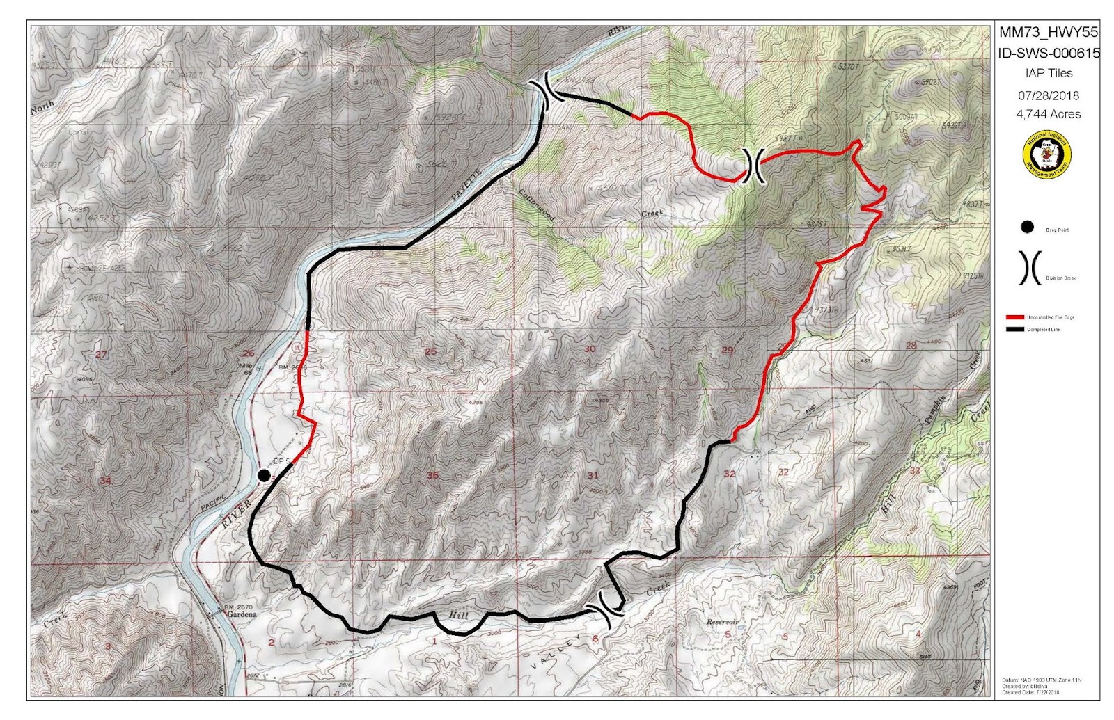
Today, fire crews will continue their efforts on increasing containment along the fire’s edge. Good progress has been made utilizing support from aerial resources and containment is currently 60%. The northeastern flank of the fire has the most potential for growth, and this is where resources will focus their attention. Crews will continue strengthening the fireline by utilizing burnout operations to remove fuel from the fire’s path. This will slow and stop the fire’s movement to the east into Jerusalem Valley.
Fire resources, both crews and vehicles, will continue to be visible along Highway 55 today.
The terrain is steep and rocky, and crews have reported that rocks and vegetation on the steep slopes have become unstable due to fire activity. These loose rocks have the potential to roll down onto the highway below. It is imperative for the safety of our firefighters and the public traveling on Highway 55 near the fire area to proceed with extreme caution as rocks and debris may be found on or near the roadway.
Aviation resources will also continue to be utilized to support firefighters on the ground for the Mile Marker 73 Highway 55 Fire. Helicopters assigned to the fire will be using the Cascade Airport as a temporary base and will be utilizing the Payette River to fill their buckets in order to support firefighters on the ground. Traffic on the highway corridor may want to stop and view the aerial operations but are reminded that stopping along the roadway is prohibited and poses a direct threat to public safety. Please keep moving, and do not stop to view the helicopters working.
The fire weather forecast today continues to call for hot and dry conditions with temperatures in the upper 90s and single digit humidity, which will increase the potential for a fire activity.
Fire resources, both crews and vehicles, will continue to be visible along Highway 55 today.
The terrain is steep and rocky, and crews have reported that rocks and vegetation on the steep slopes have become unstable due to fire activity. These loose rocks have the potential to roll down onto the highway below. It is imperative for the safety of our firefighters and the public traveling on Highway 55 near the fire area to proceed with extreme caution as rocks and debris may be found on or near the roadway.
Aviation resources will also continue to be utilized to support firefighters on the ground for the Mile Marker 73 Highway 55 Fire. Helicopters assigned to the fire will be using the Cascade Airport as a temporary base and will be utilizing the Payette River to fill their buckets in order to support firefighters on the ground. Traffic on the highway corridor may want to stop and view the aerial operations but are reminded that stopping along the roadway is prohibited and poses a direct threat to public safety. Please keep moving, and do not stop to view the helicopters working.

The fire weather forecast today continues to call for hot and dry conditions with temperatures in the upper 90s and single digit humidity, which will increase the potential for a fire activity.
Friday, July 27, 2018
National Preparedness Level has been elevated to Level 5
Given the continuing hot and dry weather and the increase in fire activity in the western U.S., the decision to move to Preparedness Level 5 depicts the complexity that fire managers are encountering to assure that adequate firefighting resources are available for protection of life, property and our nation’s natural resources.


Boise BLM responds to multiple lightning wildfires
Boise BLM responds to multiple lightning wildfires
The Boise BLM responded to five lightning ignited wildfires on
July 24 and July 25, 2018 across
the southern portion of the district.
Cat Fire
· Located approximately 13 miles
east of Duck Valley Indian Reservation, ID
· Estimated at 26,522 acres
· Cause - Lightning
· Fire resources -9 engines, 2
hand crews, 1 water tender and 4 dozers
· Air attack and air resources are
being shared with the Bruneau Fire
· No estimated containment time,
No estimated control time
Cow Fire
· Located approximately 10 miles
northeast of Jordan Valley, OR
· Estimated at 759 acres
· Cause - Lightning
· Fire resources - 3 engines, 1
water tender and 4 dozers
· Contained - 7/26/2018 at 1800,
Estimated control - 7/27/2018 at 1800
Beav Fire
· Located approximately 7 miles
southeast of Juniper Mountain, ID
· Estimated at 550 acres
· Cause - Lightning
· Contained - 7/25/2018 at 2030,
Controlled - 7/26/2018 at 1200
Big Point Fire
· Located approximately 8 miles
southeast of Juniper Mountain, ID
· Estimated at 10 acres
· Cause - Lightning
· Contained - 7/26/2018 at 1400,
Controlled - 7/26/2018 at 2000
Thursday, July 26, 2018
HWY 95 - Reopened to one-way escort with pilot car
Hwy-95 was closed due to the #KeithyFire, but is now open one-way with escort with a pilot car. Please drive slowly and carefully if driving through the area.
Twin Falls Fire Update
For Immediate Release:
July 26,
2018
Contact: Kelsey Brizendine, 208-732-7315
Twin Falls
District BLM Fire Update
Facebook: Idaho Fire Info
Twitter:
@BLMIdahoFire
(#BLMTFDFire)
(#BLMTFDFire)
Bruneau Fire
●
Location: five
miles northwest of Murphy Hot Springs
●
Size: estimated 57,300 acres
●
Contain: unknown
●
Control: unknown
●
Resources: three
dozers, 13 engines, one fuel truck, one camp crew, Three Creek Rangeland Fire
Protection Association (RFPA), two water tenders, multiple aircraft
●
Fuel
type: grass and brush
●
Fire
behavior: smoldering, creeping and backing
●
Structures
threatened: structures are not immediately threated but near the fire area
●
Cause:
lightning
As the fire behavior was relatively calm
today, firefighters were able to make good headway. Crews continue to develop
and improve containment lines, with most of the active fire remaining in the
canyons. Fire manager’s estimate the fire is about 30% contained. Due to the remote location of the fire,
updates may be delayed.
For More Information
●
Kelsey Brizendine, Fire Information and Prevention Officer,
kbrizendine@blm.gov
●
208-308-5991
Subscribe to:
Posts (Atom)